Impact Assessments of Land-Use Change and Climate Change on Ecosystem Services of Grassland

Fig. 4.1
Location of the TRHR and distribution of grassland
Methodology and Data
Models
Comprehensive Model
The comprehensive model was developed on the basis of two well-known balance equations, that is, the water balance equation and heat balance equation. Zhou deduced the regional evapotranspiration model that links the water balance equation and heat balance equation from the physical process during the energy and moisture influence of the vaporization and then constructed the natural vegetation NPP model based on the physiological characteristics (Zhou and Zhang 1996), that is, the comprehensive model. The comprehensive model can calculate the potential NPP of natural vegetation on the basis of the precipitation and net radiation received by the land surface in the study area. This model is of great significance to the reasonable use of climatic resource and fulfillment of the climatic potential productivity (Zhou and Zhang 1996). The formula of this model is as follows:
![$$\begin{aligned} {\text{NPP}} & = {\text{RDI}} \times \frac{{P_{r} R_{n} \left( {P_{r}^{2} + R_{n}^{2} + P_{r} R_{n} } \right)}}{{\left( {P_{r} + R_{n} } \right)\left( {P_{r}^{2} + R_{n}^{2} } \right)}}{\text{e}}^{{\sqrt[ - ]{9.87 + 6.25 \times RDI}}} \\ {\text{RDI}} & = \frac{{R_{n} }}{{L \cdot P_{r} }} \\ \end{aligned}$$](/wp-content/uploads/2015/10/A319577_1_En_4_Chapter_Equa.gif) where R n is the annual net radiation, P r is the annual precipitation, L is the annual latent heat of vaporization, and RDI is the radiation aridity.
where R n is the annual net radiation, P r is the annual precipitation, L is the annual latent heat of vaporization, and RDI is the radiation aridity.
Model of the Hay Yield of Grassland
There are mainly three indicators of the grassland productivity, that is, the hay yield, theoretical grazing capacity, and animal products. The hay yield, that is, the total dry matter yield of a certain area during a certain period, reflects the primary productivity of grassland and is a basic indicator of the grassland productivity. In this study, the hay yield of grassland during 2010–2030 was calculated based on NPP of grassland with the following formula:
 where, B g is the annual total hay yield per unit area (g m−2 a−1), NPP is the annual total NPP of grassland (gC m−2 a−1), S bn is the coefficient of the conversion coefficient of the grassland biomass and NPP (g/gC), which is 0.45, and S ug is the proportionality coefficient of the over ground biomass and underground biomass, which varies among different vegetation types. S ug of the alpine meadow, high-cold steppe and alpine desert is 7.91, 4.25, and 7.89, respectively. According to the location of the study area, S ug of the alpine meadow was used to calculate the grass yield.
Model of the Theoretical Grazing Capacity of Grassland
The theoretical grazing capacity of grassland during 2010–2030 was calculated on the basis of the grass yield. Since the grazing capacity of grassland is customarily represented by the unit of livestock in China, that is, the number of adult livestock that can be supported by per unit of land area every year, and the number of sheep is generally used as the unit, the grazing capacity of grassland is also represented by the number of sheep per unit of land area.
There have been many methods to calculate the theoretical grazing capacity of grassland. The estimation method of “limiting livestock based on grassland carrying capacity” can better reflect the restriction of the practical situation in the grazing districts on the livestock production, and hence, the following formula was used:
 where CA is the theoretical annual grazing capacity of grassland (Unit: number of sheep per unit of land area), G is the annual hay yield of grassland per square meter (Unit: kg/m2), and Cuse is the utilization efficiency of grass by the livestock varying among different grassland types. In this study, Cuse of the alpine meadow, high-cold steppe and alpine desert, shrubbery, and swamp meadow is 60, 50, 40, and 55 %, respectively. U G is the hay quantity needed by per unit of sheep every day (Unit: kg/d), which was set to be 2.0 kg according to the relevant criterion. DOY (Unit: d) is 365. Since the grassland is the main vegetation type in the TRHR, Cuse of the high-cold steppe was used to estimate the theoretical grazing capacity of grassland during 2010–2030.
Data Source
The data of precipitation and near-surface air temperature in the study area were simulated with the models of Coupled Model Intercomparison Project Phase 5 (CMIP5). There are three steps in the data processing. (a) The data were first selected and downloaded, including the model (CCSM4), modeling realm (atmosphere), ensemble (r6i1p1 and r5i1p1), and climatic variables (precipitation and near-surface air temperature). (b) The data of study area were then extracted and calculated. The annual average value was calculated based on the monthly data, and the annual precipitation was calculated as the sum of the monthly precipitation and then extracted 112 points covering the study area. (c) The point data with the spatial resolution 0.9° × 1.25° were interpolated in 1 km × 1 km raster using the Kriging method and were projected with the Albers 1940 coordinate system.
Results
Changing Trend of NPP of Grassland in the TRHR
There is significant spatial heterogeneity of the NPP in the TRHR, decreasing from the southeast to the northwest on the whole (Fig. 4.2). The results indicate that the NPP of grassland mainly increases in the east and southeast part, while it decreases significantly in the northwest, southwest, and middle part. There is no significant change of the NPP of grassland in most of other parts. The changing trends of NPP during every ten years indicate that the NPP changes significantly under the RCP2.6 scenario and RCP4.5 scenario, increasing in the east and southeast part to some degree and decreasing in the south part to some extent. The NPP changes slightly under the RCP6.0 scenario and RCP8.5 scenario. Under the RCP4.5 scenario, the NPP decreases obviously in the middle and south part during 2010–2020 and increases slightly during 2020–2030, indicating that there is serious desertification of the local grassland. Besides, the increase of NPP by 2030 suggests that there is some improvement in the conditions of the local grassland.
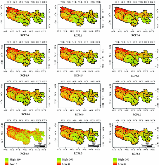
Fig. 4.2
The NPP map of the TRHR in 2010, 2020, and 2030 under the four RCPs scenarios
In this study, the influence of temperature and precipitation on the change in NPP was analyzed. The result indicates that the NPP of grassland will range from 100 to 130 g m−2 a−1 during 2010–2030. The results under different scenarios are shown as follows (Fig. 4.3).
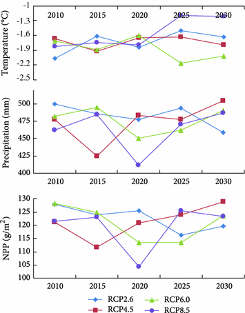
Fig. 4.3
Changing trends of the NPP of grassland, temperature, and precipitation (the average number in every year) in the TRHR during 2010–2030
The result under the RCP2.6 scenario indicates that the temperature and precipitation would present a decreasing trend during 2015–2020 and 2025–2030 and show an opposed trend during 2010–2015 and 2020–2025 (Fig. 4.3). The precipitation will fluctuate more greatly than the temperature on the whole. By contrast, the NPP will change in an opposite way during these periods, but with smaller amplitude of fluctuation. Therefore, there is a significant negative relationship between the NPP and temperature, while there is only a weak relationship between the NPP and precipitation under this scenario.
The result under the RCP4.5 scenario indicates that the NPP and precipitation show a similar changing trend, that is, a concave-down parabolic trajectory on the whole. The precipitation will fluctuate most greatly during 2010–2020, while the NPP first decreases with the precipitation and then increases rapidly after reaching a relatively low level. The NPP will decrease by 8.4 % from 2010 to 2015, but it will increase by 8.2 % from 2015 to 2020. Then, the NPP will increase slowly while fluctuating slightly during 2020–2030. Therefore, there is a significant negative relationship between the NPP and precipitation under this scenario, while the relationship between the NPP and temperature is very weak.
The result under the RCP6.0 scenario indicates that the NPP will first increase and then decrease during 2015–2025, while temperature will show an opposite changing trend during this period, as during other period, they will change in a similar way. The precipitation will show an increasing trend during 2010–2015 and 2020–2030. The NPP and precipitation will both decline obviously during 2015–2020 and reach the bottom around 2020. The NPP will decrease by 10 % in 2020 when compared with 2015, which indicates that the change in NPP is greatly influenced by the change of precipitation during this period and they are strongly correlated. The result suggests that the changing trends of the NPP are consistent with those of the precipitation on the whole, but the fluctuation range of the NPP is small, indicating that there is some lag in the response of the NPP to the change of precipitation under this scenario. According to the analysis above, the NPP responds more sensitively to the change of precipitation than to the change of temperature.
Under the RCP8.5 scenario, the temperature changes slightly during 2010–2025 and 2025–2030 and shows an increasing trend during 2020–2025. Besides, the NPP also fluctuates slightly during 2010–2025 and 2025–2030, indicating that the temperature plays a dominant role in influencing the NPP. The NPP and precipitation both fluctuate significantly during 2015–2020, and there is an obvious low ebb around 2020. The NPP decreases by 15.3 % in 2020 in comparison with 2015, indicating that there is a strong correlation between the change in NPP and the change of precipitation. During 2020–2025, the NPP, temperature, and precipitation all show an obvious increasing trend. The NPP increases by 20.4 % from 2020 to 2025 and reaches a significant peak around 2025, indicating that there is significant relationship between the change in NPP and the changes of both the precipitation and temperature. Therefore, the temperature plays a key role in influencing the change in NPP during 2010–2020 and 2025–2030, while the precipitation plays a dominant role during 2015–2020. Besides, during 2020–2025, both the temperature and precipitation greatly influence the NPP.
Changing Trend of Grass Yield of Grassland
The result under the RCP2.6 scenario indicates that the changing trend and fluctuation range of the grass yield are both pretty consistent with those of the NPP mentioned above; that is, both increase during 2015–2020 and 2025–2030 and decrease during 2010–2015 and 2020–2025 (Fig. 4.4). On the whole, the grass yield is generally above 6.3 million tons under this scenario except for the period around 2025, and the fluctuation range is not great and the average yield level is very stable.
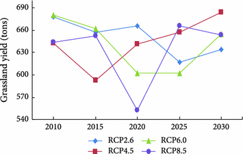
Fig. 4.4
Changing trends of grass yield of grassland in the TRHR during 2010–2030 under the four scenarios
The result under the RCP4.5 scenario indicates that the grassland yield will fluctuate greatly but will still increase slightly on the whole during 2010–2015. The grass yield will keep a stable increasing trend during 2015–2030. In comparison with the changing trend of NPP mentioned above, the changing trend of the grass yield is consistent with that of the NPP during 2015–2030, but they are not closely related during 2010–2015.
The result under the RCP6.0 scenario indicates that the grass yield will decline during 2010–2020 and then tends to increase slowly after reaching a low level around 2020, indicating that the grass yield of the TRHR will fluctuate greatly under this scenario.
The result under the RCP8.5 scenario suggests that the grass yield of the TRHR will fluctuate slightly during 2010–2015, then declines significantly, and thereafter keeps an increasing trend, but the increment will gradually decline and there may even be some slight decrease. According to the analysis above, it is predictable that the grass yield will fluctuate obviously around 2020 and decline to a very low level and will only fluctuate slightly during other periods under this scenario.
To sum up, there is a positive relationship between the grass yield and NPP of grassland in the TRHR. The change of the NPP of grassland has an impact on the grass yield, but its effects vary among different RCPs scenarios. The grass yield is very stable under the RCP2.6 scenario, generally above 6.3 million tons every year. Under the RCP4.5 and RCP6.0 scenarios, the changing trends of the grass yield and NPP of grassland are generally similar during most periods except for 2015–2020, during which their changing trends are contrary. Under the RCP8.5 scenario, the grass yield fluctuates most greatly, and the precipitation, grass yield, and NPP of grassland will all descend to the bottom around 2020, indicating that the grass yield is most greatly influenced by the precipitation under this scenario.
Analysis of the Grazing Capacity of Grassland
The theoretical grazing capacity during 2010–2030 was analyzed in this study. The grazing capacity of grassland in the TRHR was calculated on the basis of the grass yield. The result indicates that the theoretical grazing capacity ranges from 4 to 5 million sheep under the four scenarios (Fig. 4.5).
Fig. 4.5
Theoretical grazing capacity in the TRHR during 2010–2030 (ten thousand sheep)
The result under the RCP2.6 scenario indicates that the theoretical grazing capacity in the TRHR will show a significant decreasing trend and reach the minimum in 2017, and it will then increase rapidly during 2018–2021 but will thereafter keep a decline trend on the whole (Fig. 4.5). Besides, the interannual fluctuation range is very great under this scenario. According to the changing trends of the temperature and precipitation mentioned above, the grazing capacity responds very slowly to the change of temperature within a certain scope and there is no significant relationship between them, while the grazing capacity shows a changing trend similar to that of the precipitation. The result indicates that, under the condition of no great fluctuation in the temperature, the grazing capacity mainly depends on the precipitation, which is consistent with the actual condition that the local animal husbandry is mainly restricted by the water resource.
The result under the RCP4.5 scenario indicates that the grazing capacity fluctuates greatly during 2010–2015, but the fluctuation range will gradually decrease with the time. It shows an increasing trend during 2015–2025, especially during 2019–2025, and there will be a stable and continuous increase. The grazing capacity will first decrease sharply and then increase rapidly during 2025–2030. On the whole, the grazing capacity fluctuates very greatly and the stability is very low under this scenario. It suggests that the grazing capacity of the local grassland increases with the precipitation within a certain scope, beyond which the temperature will play a more important role. In comparison with the changing trends of the temperature and precipitation mentioned above, it can be seen that the influence of the temperature on the grazing capacity is always very significant under this scenario, while that of the precipitation is only significant during 2015–2025.
The result under the RCP6.0 scenario indicates that the grazing capacity shows a decreasing trend on the whole during 2010–2020, during which there is great fluctuation. The grazing capacity will first increase and then decrease during 2020–2030, and it shows a decreasing trend on the whole under this scenario. In comparison with the changing trends of the temperature and precipitation mentioned above, the changing trend of the grazing capacity is more consistent with that of the precipitation. However, during 2020–2030, the change of the grazing capacity is negatively related with the change of temperature, and it responds very slowly to the change of precipitation, and even not obviously. It indicates that the precipitation has more important impacts on the grazing capacity when the temperature is within a certain range; but on condition that the temperature decreases by a certain degree, the precipitation will only play a secondary role.
The result under the RCP8.0 scenario indicates that the local grazing capacity will fluctuate slightly during 2010–2015, but without significant change on the whole. It will continually decrease during 2016–2020 and reach the bottom around 2020 and then will keep increasing and finally fluctuate around 4.5 million sheep. According to the changing trends of the temperature and precipitation, the changing trend of the grazing capacity is more consistent with that of the precipitation, indicating that the precipitation plays a more important role in influencing the grazing capacity than the temperature does.
In summary, the precipitation plays a dominant role in influencing the grazing capacity under the RCP2.6 scenario, and the water resource is the main limiting factor of the development of the local animal husbandry. The precipitation has limited impacts on the development of the local animal husbandry under the RCP4.5 scenario. The theoretical grazing capacity increases with the precipitation within a certain scope, beyond which the temperature will play a more important role. The precipitation and temperature both have some influence on the grazing capacity under the RCP6.0 scenario. The precipitation plays a more important role when the temperature reaches a certain scope and vice versa. The precipitation plays a more important role in influencing the grazing capacity under the RCP8.5 scenario. On the whole, the theoretical grazing capacity in the TRHR ranges from 4 to 5 million sheep.
Summary
This study estimated the NPP of grassland in the TRHR under four RCPs scenarios based on the comprehensive model and estimated the local grass yield and theoretical grazing capacity in the future. Besides, the future changing trends of the NPP, grass yield, and grazing capacity were analyzed under four scenarios. In this paper, we draw the following conclusions.
There are very complex influences of the precipitation and temperature on the grassland productivity, and the effects of the precipitation and temperature on the NPP, grass yield, and grazing capacity are very complex and unstable under different scenarios. For example, the theoretical grazing capacity in 2029 is 4.1072 million sheep under the RCP2.6 scenario, while it is 4.6527 million sheep under the RCP4.5 scenario, which also differs greatly under another two scenarios.
The grassland productivity in the TRHR is unstable on the whole. The grass yield is greatly influenced by the fluctuation of the precipitation and the temperature which also plays a more important role and subsequently influences the grazing capacity. This conclusion is consistent with that of the previous research on the changing trend of vegetation NPP in the past 50 years in the Yellow River headwater area, which was carried out by Yao et al.(2011), indicating that the precipitation plays a dominant role in influencing the grassland productivity in the TRHR.
The grassland productivity in the TRHR will decrease slightly during 2010–2020, especially around 2020 when there will be a minimum, while the grazing capacity will first increase and then decrease during this period under all the scenarios except the RCP8.5 scenario. According to the analysis of the changing trend of the grazing capacity, there is a dramatic change in the grazing capacity in the TRHR due to the influence of the climatic factors. Therefore, it is necessary to reinforce the control on the grazing capacity, eliminate some livestock species in time, and replace the dominant grass species with the grass species that can better adapt to the climatic change. Besides, it is necessary to prepare for the various responses to the climatic change and formulate the artificial intervention mechanism as early as possible so as to reasonably guide the development of the local animal husbandry.
This study forecasted and analyzed the grassland NPP, hay yield of grasslands, and theoretical grazing capacity with the comprehensive model on the basis of the simulation of temperature and precipitation under the four scenarios. The research result is only obtained on the basis of the hydrothermal conditions, while in fact various factors, such as the soil, terrain, and solar radiation, all have some impacts on the grassland NPP. Therefore, there is still some limitations in the result of this study, and it is necessary to carry out more in-depth research works on the modification of the simulation result with the comprehensive model through including more other factors.
Estimated Changes in Economic Returns of Livestock Production in the TRHR of China
Introduction
Both the global and regional climate change have greatly undermined the terrestrial landscapes, ecological processes, and ecosystem services (Jentsch and Beierkuhnlein 2008), which have subsequently threatened not only the human societies but also the natural environment itself by the recondite feedback effects (Drinkwater et al. 2010). There have been dramatic changes in the climatic conditions of China, which will continue to last for a long time in the future. The atmospheric temperature of China has increased by 0.5–0.8 °C in the twentieth century, with the upper limit exceeding the global average level. Meanwhile, the precipitation has continuously decreased in northern part of China while increased greatly in the southern and southeast part of China. Additionally, the extreme climate and subsequent natural disasters have also showed a longitudinal distribution pattern. A number of researchers have reported the impacts of climate change on various factors of the ecological and social systems (Yue et al. 2011), such as terrestrial surface (Briner et al. 2012), the market price (Fleischer and Sternberg 2006), and externality of public goods and even the political negotiations among various stakeholders (Rustad 2008).
Climate change associated with human adaptive activities, especially the social agents’ decisions on land use, has exerted synergistic impacts on the land surface at different scales (Rounsevell and Reay 2009). There are generally two approaches through which the climate change influences the dynamic land surface properties, that is, the natural processes and human adaptive behaviors. The natural processes, for example, the change of thermodynamic properties and hydrological changes, will alter the terrestrial land surface at the long-term scale, and the inherent properties of different land-cover types limit the land-use activities of human beings, while the human adaptive behaviors may mitigate the adverse effects of climate change through changing the land-use practices. For instance, the herdsmen prefer pasturing sheep on the grassland to other land-cover types, and therefore, they may transform the cultivated land and forest land into grassland so as to adapt to the climate change and obtain more ecosystem services. However, there has been very limited knowledge on the impacts of climate change on the land-use dynamics through disturbing microagents’ behaviors so far. Besides, climate change has also influenced the behaviors of government agents, who have taken measures to mitigate the impacts of the climate change and may subsequently influence the behaviors of other agents. For example, the long-term strategic development policy in the western region of China has greatly promoted the ecological restoration and protection of the regional ecosystem; the subsequent national-wide policies of Grain for Green (GFG) and Overgrazing Forbidden have made remarkable progresses in the land planning and ecological construction through compensating farmers and herdsmen for the change of their unreasonable land-use practices; what is more important is that the establishment of the TRHR nature reserve has imposed restrictions on the local human land-use practices and consequently protected the local ecological environment.
It is necessary to analyze the driving mechanism of social agents’ behaviors and clarify their behaviors or decision algorithms with a proper model in order to more accurately study the temporal and spatial transitions of land use under the impacts of climate change and social agents’ behaviors. The agent-based model (ABM) is a mainstream model to specify the behaviors of agents. Although there have been many ABM studies on the regional and local simulation, especially in the urban areas and transition zones between cultivated land and grassland, it is still necessary to carry out more in-depth ABM studies in areas without significant land-use/land-cover change (LUCC) and easy-distinguished agents. Besides, previous researches on the identification and parameterization of the agents’ behaviors have mainly relied on the mathematical or econometric theories, which are different from the thinking ways of human beings from the ethological perspective in the real life. What is more, agents will actually choose the land-use practices for a targeted land parcel according to their own or neighbors’ successful land-use experiences, which has served as the theoretical basis of the case-based reasoning (CBR) in this study.
The grassland is the dominant land-use type in this area, accounting for 71.5 % of the TRHR and having a total decrement of 0.03 % in the past two decades, while the unused land accounted for 16.5 % of the study area and increased by 0.10 % in the same period. The high and mediate coverage grasslands have experienced continuous shrinkage, while the low coverage grassland area has had continually expanded. The spatial pattern of land-use change in the past decades was characterized by the grassland degradation in the middle and east regions and the shrinkage of the water body in the north and west regions (Xu et al. 2008). Besides, the economy in the study area has experienced unprecedented development during the past 20 years. The gross domestic product (GDP) in 2010 is 15 times of that in 1990. The animal husbandry is the dominant sector in the primary industry of this region, appropriately accounting for 79.5 % of the total output of the primary industry.
This study has aimed to analyze the impacts of climate change and variability and corresponding agents’ adaptive land-use decisions on the land surface in the TRHR with the ABM. This paper will firstly extract the main agents based on the analysis of production resource endowments and socioeconomic situation in the study area and then parameterizes the behaviors of various agents by utilizing county-level statistical data and household survey data. Thereafter, the ABM model was constructed and used to simulate the land-use change in the next 50 years. The economic benefits of agents are also discussed in this paper.
Data and Methodology
Data Collection
The data used in this study mainly include the land-use data, socioeconomic and demographic information, the natural environment, and climatic conditions, all of which were derived from the following sources: (1) Environmental Science Data Center of Chinese Academy of Sciences, which offers the datasets of land use, digital elevation model (DEM), topography, the distance to water and road, and climate and soil properties; (2) statistical yearbooks, such as Qinghai Province Statistical Yearbook, China Agricultural Yearbook, and China Animal Husbandry Yearbook, which mainly contain the population, GDP, food production, and animal husbandry production; (3) household survey data, which were obtained from the household survey implemented by the research team in August and October 2012 with the stratified random sampling method performance. Three counties were selected as the sample sites to conduct the survey, which aims to identify the agents and parameterize their behaviors. The questionnaires have been modified after the pretest. Besides, an intraday examination was carried out on the result of questionnaires so as to revise the inconsistent or unreasonable answers with the retelephone investigation. This could not only save a lot of human resources and finance but also ensure the representativeness and reliability of the samples.
Identification of Agents
It is more difficult to identify the agents in the study area than in other regions where the agents such as farmers and herdsmen have inherent differences. In the study area, most people are herdsmen who rely on the grassland, and it seems that there are no absolute differences among these individuals. However, the statistical analysis and preinvestigation indicate that the herdsmen are different in the economic background and production resources, which would influence their land-use decisions. Therefore, based on the analysis of the socioeconomic background, natural environment conditions, and resources endowments, all the counties in the study area were classified into three categories, that is, the traditional development area, animal husbandry dominated area, and restricted development area. By doing this, the major agents can be extracted from each category, including the farmer agent, herdsman agent, and hominid agent.
The farmer agents are mainly located in the traditional development areas, eastern regions. They possess abundant labor force, production resources, and relatively large cultivated land area, which help them get a higher economic return from diverse income sources. The herdsman agents mainly dwell in the animal husbandry dominated areas, where the cultivated land shares a very small proportion, but the grassland occupies more than 70 % of the total area of these regions. So the herdsmen extremely rely on the grassland to develop the animal husbandry industry to get the revenue for supporting their families. Subsequently, the proportion of animal husbandry output to the primary industry output is higher than other sectors due to the intensive resource utilization and collective land-use practices. The hominid agents were identified according to the habitat properties. The hominid agents were located in the counties where the social and natural ecological systems are extremely fragile. These counties are characterized by the harsh climatic conditions, lower economic levels and human resource, and lack of production resource endowments. Therefore, the agents in these areas would heavily rely on the natural conditions rather than the land-use activities to support their life.
Agents’ Behaviors
The general behavior rules of how the agents decide the land-use practices for a targeted land parcel were introduced first, and then, the individual behavior rules that varied from each agent were designed and specified with the diverse characteristics. At last, the impacts of the government agent’s behaviors on other agents’ decision through punishment and compensation were described.
Generally, all the agents have the same procedures for determining the land-use practices for a certain land parcel. It means that each agent will choose a land-use type for a land parcel at the beginning of each simulation step; then, the agent will calculate the maximum combined economic and social benefit at the end of each step to decide which land-use type should be chosen for this land parcel. Thereafter, the agent chooses a certain land-use type according to the land-use decision algorithm. Finally, the agent will decide whether or not to sell or buy land parcels based on the estimation of economic account (Polhill et al. 2010).
The individual behavior rules are different among agents due to the variation in economic background, natural conditions, and production resource endowments, which are vital to the design of the land-use decision algorithm. There are three categories of individual decision algorithms in terms of satisfaction, imitation, and CBR strategies (Izquierdo et al. 2004). It was assumed that agents have different probabilities to choose the decision algorithm according to the results of the field survey. Specifically speaking, if the benefits of the land-use decision have reached the agents’ expectation, the agents will choose the satisfactory land-use strategy, that is, choose the same land-use type in last year. Or else, the agents will get certain probabilities to choose the imitation strategy or CBR strategy if the expectation is not realized (Izquierdo et al. 2004). As for the imitation strategy, the agents will imitate the successful land-use practices of their neighbors. But actually all the agents are more willing to determine the land use for the land parcel according to their own historical experiences. Therefore, they will get a relatively higher probability to choose the CBR strategy.